Share I belong to a group which meets every Wednesday evening at the Kinsman Centre on Waggoners Lane. Will this be accessible over the summer months or will Waggoners Lane be closed to traffic at some point? on Facebook
Share I belong to a group which meets every Wednesday evening at the Kinsman Centre on Waggoners Lane. Will this be accessible over the summer months or will Waggoners Lane be closed to traffic at some point? on X (formerly Twitter)
Share I belong to a group which meets every Wednesday evening at the Kinsman Centre on Waggoners Lane. Will this be accessible over the summer months or will Waggoners Lane be closed to traffic at some point? on Linkedin
Email I belong to a group which meets every Wednesday evening at the Kinsman Centre on Waggoners Lane. Will this be accessible over the summer months or will Waggoners Lane be closed to traffic at some point? link
I belong to a group which meets every Wednesday evening at the Kinsman Centre on Waggoners Lane. Will this be accessible over the summer months or will Waggoners Lane be closed to traffic at some point?
Denise Watson
asked
about 5 years ago
Hi Denise,
We’re sorry we didn’t see your question until now. The Waggoners-Rookwood-Odell intersection has been closed since June 28 so that work can begin on the roundabout. And Waggoner will also be closed from Rookwood to Hanwell while this work is happening. We’re sorry for the inconvenience.
Share Is the parking lot at the Rookwood Ave entrance currently closed? Is the entrance open to pedestrian traffic wishing to use the disc golf facilities? on Facebook
Share Is the parking lot at the Rookwood Ave entrance currently closed? Is the entrance open to pedestrian traffic wishing to use the disc golf facilities? on X (formerly Twitter)
Share Is the parking lot at the Rookwood Ave entrance currently closed? Is the entrance open to pedestrian traffic wishing to use the disc golf facilities? on Linkedin
Email Is the parking lot at the Rookwood Ave entrance currently closed? Is the entrance open to pedestrian traffic wishing to use the disc golf facilities? link
Is the parking lot at the Rookwood Ave entrance currently closed? Is the entrance open to pedestrian traffic wishing to use the disc golf facilities?
Ian Daniels
asked
about 5 years ago
Thanks for the question! There is currently some construction work happening in the parking lot but it will remain open until June 28 and pedestrian access will be maintained to the park. The disc golf course is not expected to be impacted by construction and will remain open.
Share Can you show a map or describe the new routing of the buses? I'm having trouble understanding where the bus will go if the bus stop on Hanwell Rd. is still being served seeing as it's up by Waggoner's Ln. (APEGNB) and there's nowhere to turn. on Facebook
Share Can you show a map or describe the new routing of the buses? I'm having trouble understanding where the bus will go if the bus stop on Hanwell Rd. is still being served seeing as it's up by Waggoner's Ln. (APEGNB) and there's nowhere to turn. on X (formerly Twitter)
Share Can you show a map or describe the new routing of the buses? I'm having trouble understanding where the bus will go if the bus stop on Hanwell Rd. is still being served seeing as it's up by Waggoner's Ln. (APEGNB) and there's nowhere to turn. on Linkedin
Email Can you show a map or describe the new routing of the buses? I'm having trouble understanding where the bus will go if the bus stop on Hanwell Rd. is still being served seeing as it's up by Waggoner's Ln. (APEGNB) and there's nowhere to turn. link
Can you show a map or describe the new routing of the buses? I'm having trouble understanding where the bus will go if the bus stop on Hanwell Rd. is still being served seeing as it's up by Waggoner's Ln. (APEGNB) and there's nowhere to turn.
Gracey
asked
about 5 years ago
Hi, there! Buses will have to detour as part of the full closure of Waggoner’s Lane in July/August.
The 12N will follow Smythe/Saunders/Parkhurst/Hanwell/Woodstock Rd
The 13S will follow Woodstock/Hanwell/Parkhurst/Saunders/Smythe
With respect to stops near APEGNB, new temporary transit stops will be added by the Hanwell/Parkhurst intersection during this transit detour time.
Share Where are the seniors suppose to catch a bus by the Superstore . I am not able to walk far. on Facebook
Share Where are the seniors suppose to catch a bus by the Superstore . I am not able to walk far. on X (formerly Twitter)
Share Where are the seniors suppose to catch a bus by the Superstore . I am not able to walk far. on Linkedin
Email Where are the seniors suppose to catch a bus by the Superstore . I am not able to walk far. link
Where are the seniors suppose to catch a bus by the Superstore . I am not able to walk far.
Sandra Holland
asked
about 5 years ago
Hi! As part of the detouring of transit for July/August (with the full closure of Waggoner’s Lane), new temporary transit stops will be added to Smythe Street adjacent to SuperStore.
Share Am interested in understanding how the following roads, driveways and trails will work in relation to the proposed roundabout (see below). For this, I believe a rendering which shows Rookwook from Woodfield to Waggonner's would be highly beneficial.
-access to the two new buildings which are going up on the corner of Rookwood and Waggonner's (one currently under construction)
- Trail that runs behind the superstore and across Rookwood (I understand some modifications proposed)
-driveways to the professional building across the street from the construction site, the Curling Club
-access to the proposed school that would be part of at least one of the Exhibition Grounds development options
-access to the Exhibition Grounds residential, etc. development (if Rookwood will be part of any scenario for access)
-any traffic signals or traffic calming measures that will be in place along Rookwood, including the Saunders/Parkhurst intersection. (How will this work when the portion of Rookwood is adjusted to one way traffic)
-Please add any timelines for when the lights/one way traffic, traffic calming, etc. will be put in place if not at the same time as the construction of the traffic circle this fall.
Also, please indicate what studies will be done to gauge and manage increased traffic on Inglewood and Parkhurst as a result of the aforementioned. Thank you!
Patricia Field on Facebook
Share Am interested in understanding how the following roads, driveways and trails will work in relation to the proposed roundabout (see below). For this, I believe a rendering which shows Rookwook from Woodfield to Waggonner's would be highly beneficial.
-access to the two new buildings which are going up on the corner of Rookwood and Waggonner's (one currently under construction)
- Trail that runs behind the superstore and across Rookwood (I understand some modifications proposed)
-driveways to the professional building across the street from the construction site, the Curling Club
-access to the proposed school that would be part of at least one of the Exhibition Grounds development options
-access to the Exhibition Grounds residential, etc. development (if Rookwood will be part of any scenario for access)
-any traffic signals or traffic calming measures that will be in place along Rookwood, including the Saunders/Parkhurst intersection. (How will this work when the portion of Rookwood is adjusted to one way traffic)
-Please add any timelines for when the lights/one way traffic, traffic calming, etc. will be put in place if not at the same time as the construction of the traffic circle this fall.
Also, please indicate what studies will be done to gauge and manage increased traffic on Inglewood and Parkhurst as a result of the aforementioned. Thank you!
Patricia Field on X (formerly Twitter)
Share Am interested in understanding how the following roads, driveways and trails will work in relation to the proposed roundabout (see below). For this, I believe a rendering which shows Rookwook from Woodfield to Waggonner's would be highly beneficial.
-access to the two new buildings which are going up on the corner of Rookwood and Waggonner's (one currently under construction)
- Trail that runs behind the superstore and across Rookwood (I understand some modifications proposed)
-driveways to the professional building across the street from the construction site, the Curling Club
-access to the proposed school that would be part of at least one of the Exhibition Grounds development options
-access to the Exhibition Grounds residential, etc. development (if Rookwood will be part of any scenario for access)
-any traffic signals or traffic calming measures that will be in place along Rookwood, including the Saunders/Parkhurst intersection. (How will this work when the portion of Rookwood is adjusted to one way traffic)
-Please add any timelines for when the lights/one way traffic, traffic calming, etc. will be put in place if not at the same time as the construction of the traffic circle this fall.
Also, please indicate what studies will be done to gauge and manage increased traffic on Inglewood and Parkhurst as a result of the aforementioned. Thank you!
Patricia Field on Linkedin
Email Am interested in understanding how the following roads, driveways and trails will work in relation to the proposed roundabout (see below). For this, I believe a rendering which shows Rookwook from Woodfield to Waggonner's would be highly beneficial.
-access to the two new buildings which are going up on the corner of Rookwood and Waggonner's (one currently under construction)
- Trail that runs behind the superstore and across Rookwood (I understand some modifications proposed)
-driveways to the professional building across the street from the construction site, the Curling Club
-access to the proposed school that would be part of at least one of the Exhibition Grounds development options
-access to the Exhibition Grounds residential, etc. development (if Rookwood will be part of any scenario for access)
-any traffic signals or traffic calming measures that will be in place along Rookwood, including the Saunders/Parkhurst intersection. (How will this work when the portion of Rookwood is adjusted to one way traffic)
-Please add any timelines for when the lights/one way traffic, traffic calming, etc. will be put in place if not at the same time as the construction of the traffic circle this fall.
Also, please indicate what studies will be done to gauge and manage increased traffic on Inglewood and Parkhurst as a result of the aforementioned. Thank you!
Patricia Field link
Am interested in understanding how the following roads, driveways and trails will work in relation to the proposed roundabout (see below). For this, I believe a rendering which shows Rookwook from Woodfield to Waggonner's would be highly beneficial.
-access to the two new buildings which are going up on the corner of Rookwood and Waggonner's (one currently under construction)
- Trail that runs behind the superstore and across Rookwood (I understand some modifications proposed)
-driveways to the professional building across the street from the construction site, the Curling Club
-access to the proposed school that would be part of at least one of the Exhibition Grounds development options
-access to the Exhibition Grounds residential, etc. development (if Rookwood will be part of any scenario for access)
-any traffic signals or traffic calming measures that will be in place along Rookwood, including the Saunders/Parkhurst intersection. (How will this work when the portion of Rookwood is adjusted to one way traffic)
-Please add any timelines for when the lights/one way traffic, traffic calming, etc. will be put in place if not at the same time as the construction of the traffic circle this fall.
Also, please indicate what studies will be done to gauge and manage increased traffic on Inglewood and Parkhurst as a result of the aforementioned. Thank you!
Patricia Field
about 5 years ago
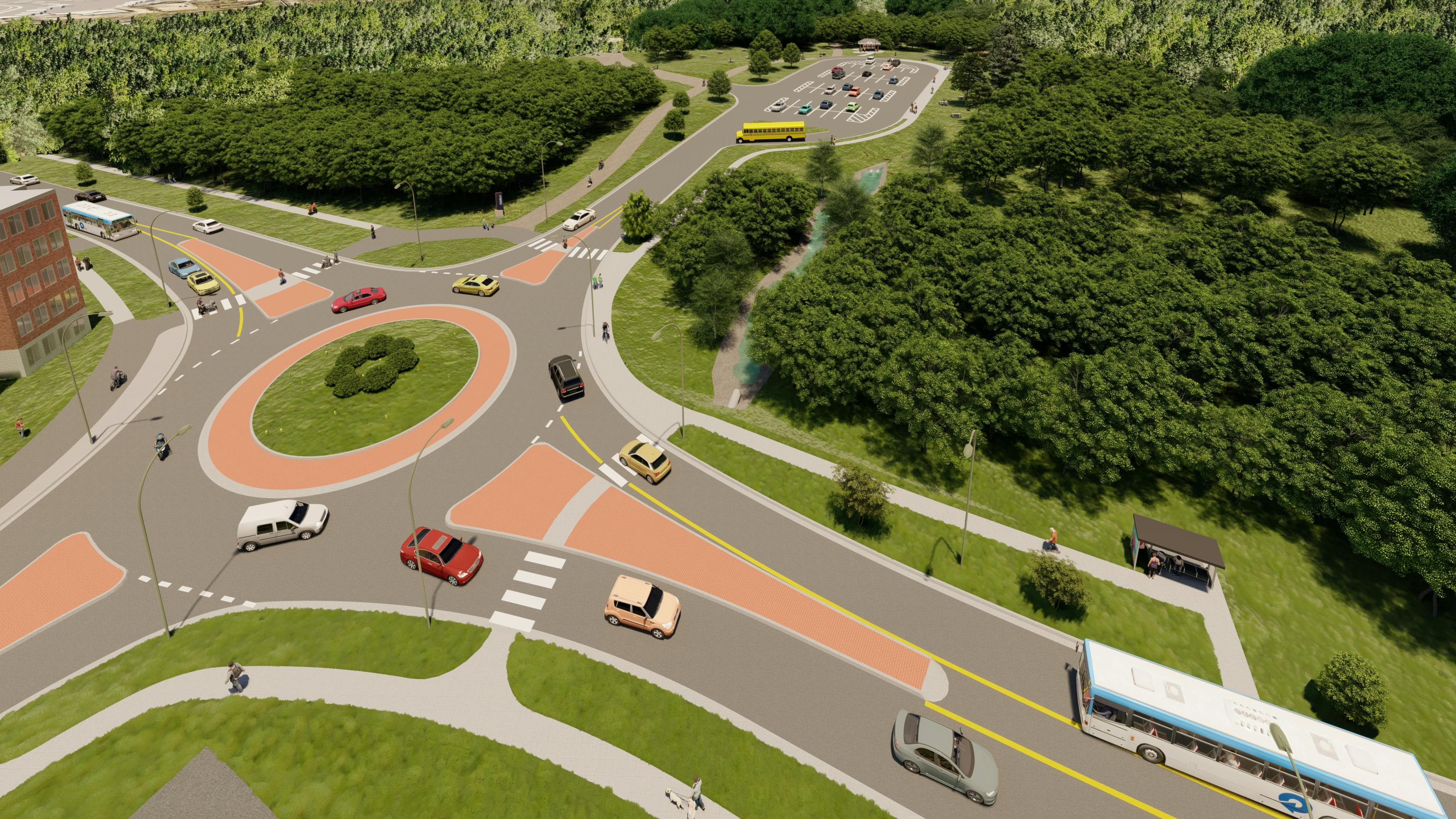
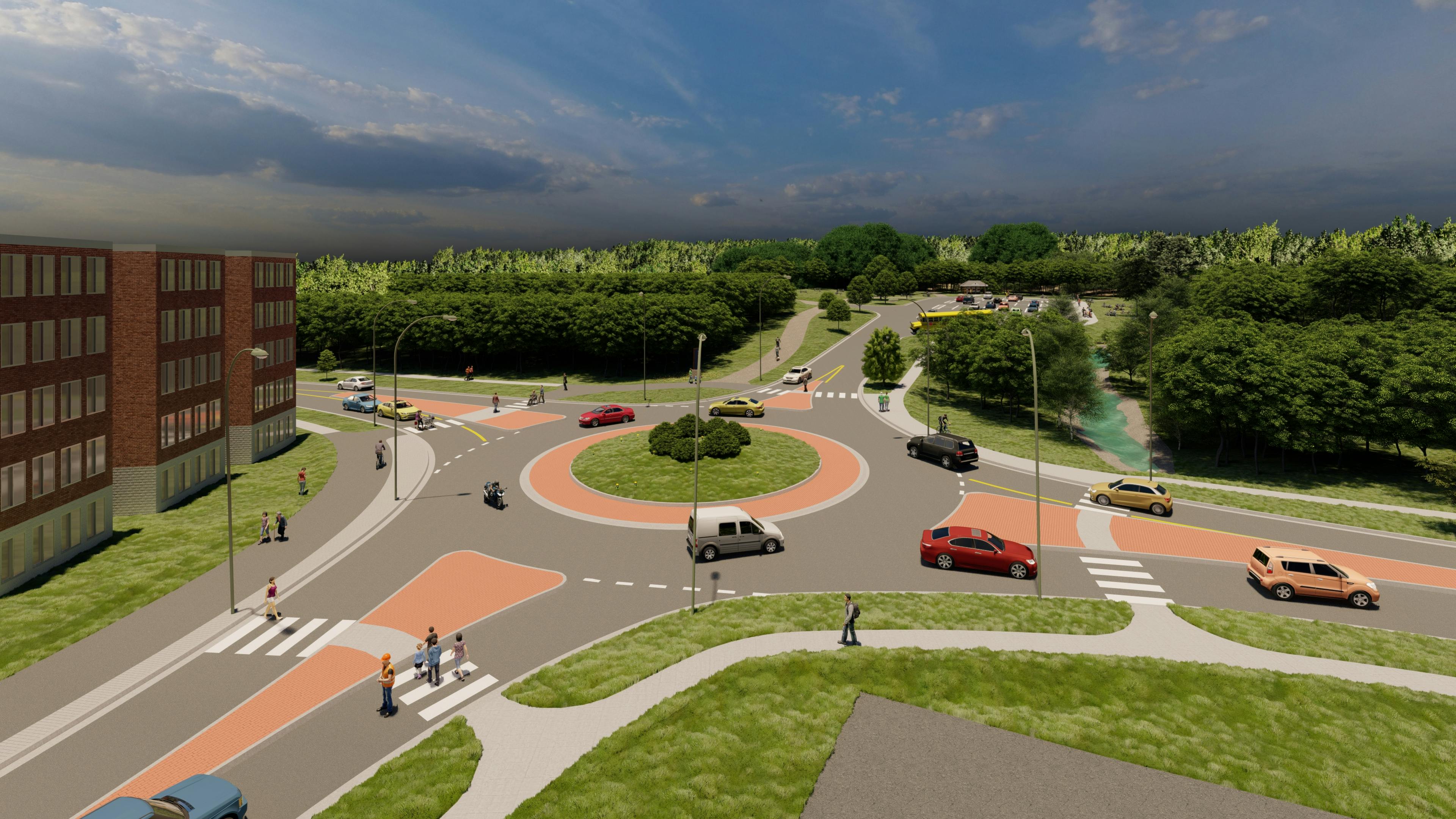
Hi Patricia. Thank you for your message and questions about this project! Unfortunately we do not have a rendering of Rookwood between Waggoners and Woodfield so I have tried to summarize answers to your questions below:
- The 2 new buildings at the north-east corner of Waggoner’s/Rookwood will be accessed by 1 new development driveway on the east side of Rookwood, directly opposite the existing Caris driveway on the west side of the street (this is approximately 70m to the north of the new roundabout). The other 2 existing driveways on the east side of Rookwood, adjacent to the new development will be removed as part of the re-curbing of Rookwood Avenue;
- There are no changes to the Valley Trail between Smythe Street and Hanwell Road other than the roadway crossing of Rookwood gets shorter in conjunction with the narrowing of Rookwood Avenue which improves trail user safety;
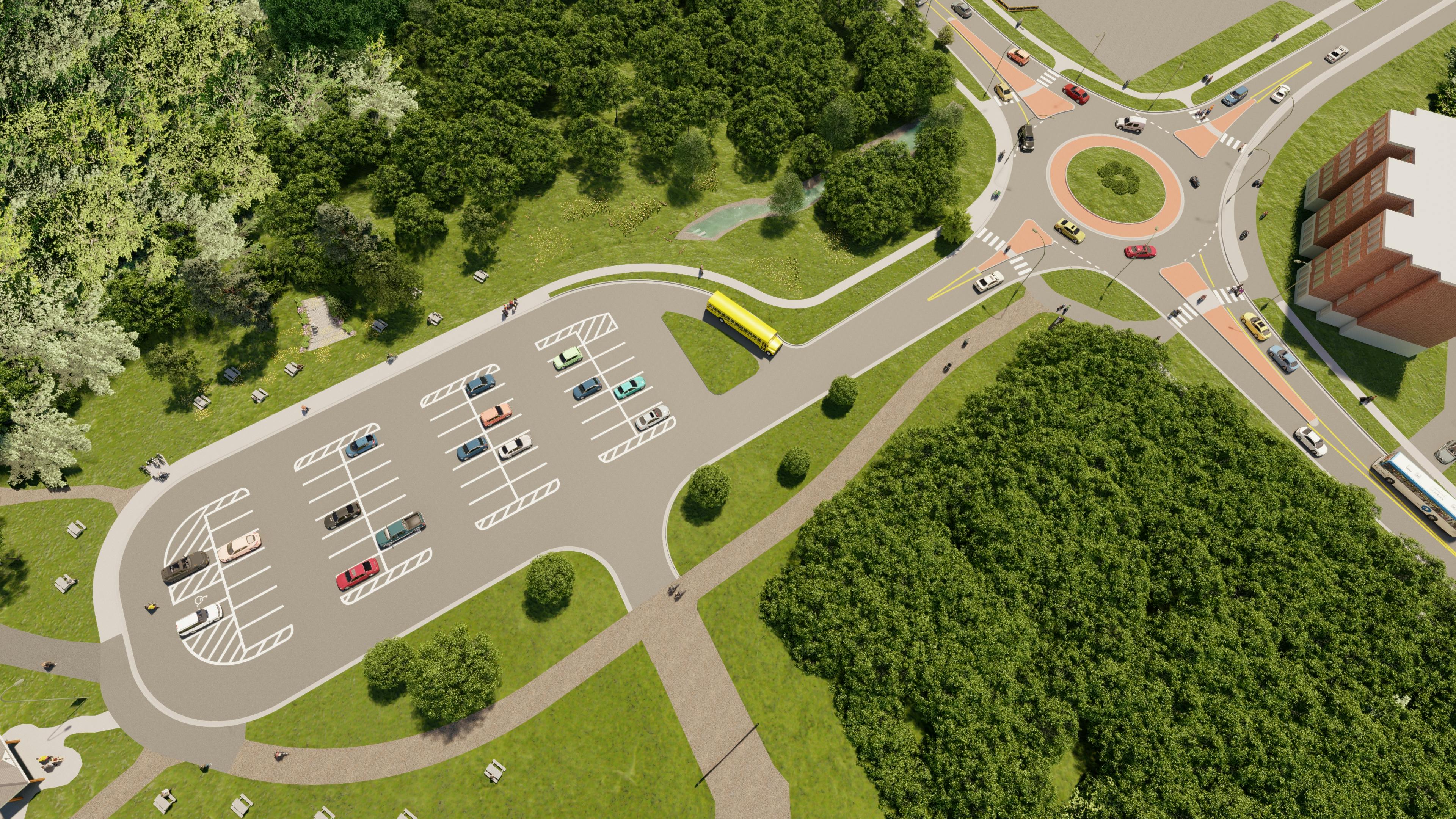
- A new trail is being constructed on the east side of Rookwood Avenue between Odell Park and Wilmot Park to improve accessibility for walkers and cyclists between the Valley Trail and the 2 parks. The trail will be constructed from Odell Park to the southern Woodfield Crescent intersection as part of the 2021 work and we anticipate finishing the trail connection to Wilmot Park next year;
- There are no significant changes proposed to any of the other commercial driveway accesses along Rookwood Avenue;
- Rookwood will remain a 2-way street; however, with a narrower street width, it will provide a traffic calming effect in lowering travel speeds of drivers;
- There are no planned traffic signals on Rookwood Avenue. The City follows national engineering standards when determining and planning for future traffic signal installations and we do not anticipate any new signals being warranted on Rookwood Avenue for the foreseeable future.
- One of the original re-development options for the NBEX did contemplate a potential future access to the NBEX grounds directly from Rookwood. This was presented as a possible idea and the NBEX study did not undertake a detailed traffic analysis to determine how this would function or what other modifications may be required to support an access to the NBEX lands. If an access is contemplated to the NBEX grounds in the future, a traffic study will be required to evaluate its impact. None of the final 3 development concepts presented in April 2021 included any vehicular access directly to Rookwood.
- Staff continue to monitor traffic on residential streets; we do not anticipate that the roundabout or future construction of the 2 new apartment buildings will significantly change traffic patterns along Inglewood or Parkhurst.
Share When I went to the advisory meeting, the planner talked about the walking trail that will eventually connect Odell to Wilmot park and that this would be safer for pedestrians, however, all the children who walk to Connaught St School from Sunshine Gardens would be required to cross Rookwood just to get to the walking trail. It would make more sense that they remain on the current side with the sidewalk for safety. This would also impact where they are most likely to cross the roundabout.
My other concern is whether a crossing guard will remain at the roundabout, where they would be installed and would they help the children navigate more than one of the areas that need to be crossed.
I am also concerned about where the driveway to the ridiculous apartment complex will exit, how this will impact children trying to cross with cars trying to merge into a busy traffic route and if sight lines will be impacted by this large apartment building by those trying to cross. on Facebook
Share When I went to the advisory meeting, the planner talked about the walking trail that will eventually connect Odell to Wilmot park and that this would be safer for pedestrians, however, all the children who walk to Connaught St School from Sunshine Gardens would be required to cross Rookwood just to get to the walking trail. It would make more sense that they remain on the current side with the sidewalk for safety. This would also impact where they are most likely to cross the roundabout.
My other concern is whether a crossing guard will remain at the roundabout, where they would be installed and would they help the children navigate more than one of the areas that need to be crossed.
I am also concerned about where the driveway to the ridiculous apartment complex will exit, how this will impact children trying to cross with cars trying to merge into a busy traffic route and if sight lines will be impacted by this large apartment building by those trying to cross. on X (formerly Twitter)
Share When I went to the advisory meeting, the planner talked about the walking trail that will eventually connect Odell to Wilmot park and that this would be safer for pedestrians, however, all the children who walk to Connaught St School from Sunshine Gardens would be required to cross Rookwood just to get to the walking trail. It would make more sense that they remain on the current side with the sidewalk for safety. This would also impact where they are most likely to cross the roundabout.
My other concern is whether a crossing guard will remain at the roundabout, where they would be installed and would they help the children navigate more than one of the areas that need to be crossed.
I am also concerned about where the driveway to the ridiculous apartment complex will exit, how this will impact children trying to cross with cars trying to merge into a busy traffic route and if sight lines will be impacted by this large apartment building by those trying to cross. on Linkedin
Email When I went to the advisory meeting, the planner talked about the walking trail that will eventually connect Odell to Wilmot park and that this would be safer for pedestrians, however, all the children who walk to Connaught St School from Sunshine Gardens would be required to cross Rookwood just to get to the walking trail. It would make more sense that they remain on the current side with the sidewalk for safety. This would also impact where they are most likely to cross the roundabout.
My other concern is whether a crossing guard will remain at the roundabout, where they would be installed and would they help the children navigate more than one of the areas that need to be crossed.
I am also concerned about where the driveway to the ridiculous apartment complex will exit, how this will impact children trying to cross with cars trying to merge into a busy traffic route and if sight lines will be impacted by this large apartment building by those trying to cross. link
When I went to the advisory meeting, the planner talked about the walking trail that will eventually connect Odell to Wilmot park and that this would be safer for pedestrians, however, all the children who walk to Connaught St School from Sunshine Gardens would be required to cross Rookwood just to get to the walking trail. It would make more sense that they remain on the current side with the sidewalk for safety. This would also impact where they are most likely to cross the roundabout.
My other concern is whether a crossing guard will remain at the roundabout, where they would be installed and would they help the children navigate more than one of the areas that need to be crossed.
I am also concerned about where the driveway to the ridiculous apartment complex will exit, how this will impact children trying to cross with cars trying to merge into a busy traffic route and if sight lines will be impacted by this large apartment building by those trying to cross.
Amy Ferguson
asked
about 5 years ago
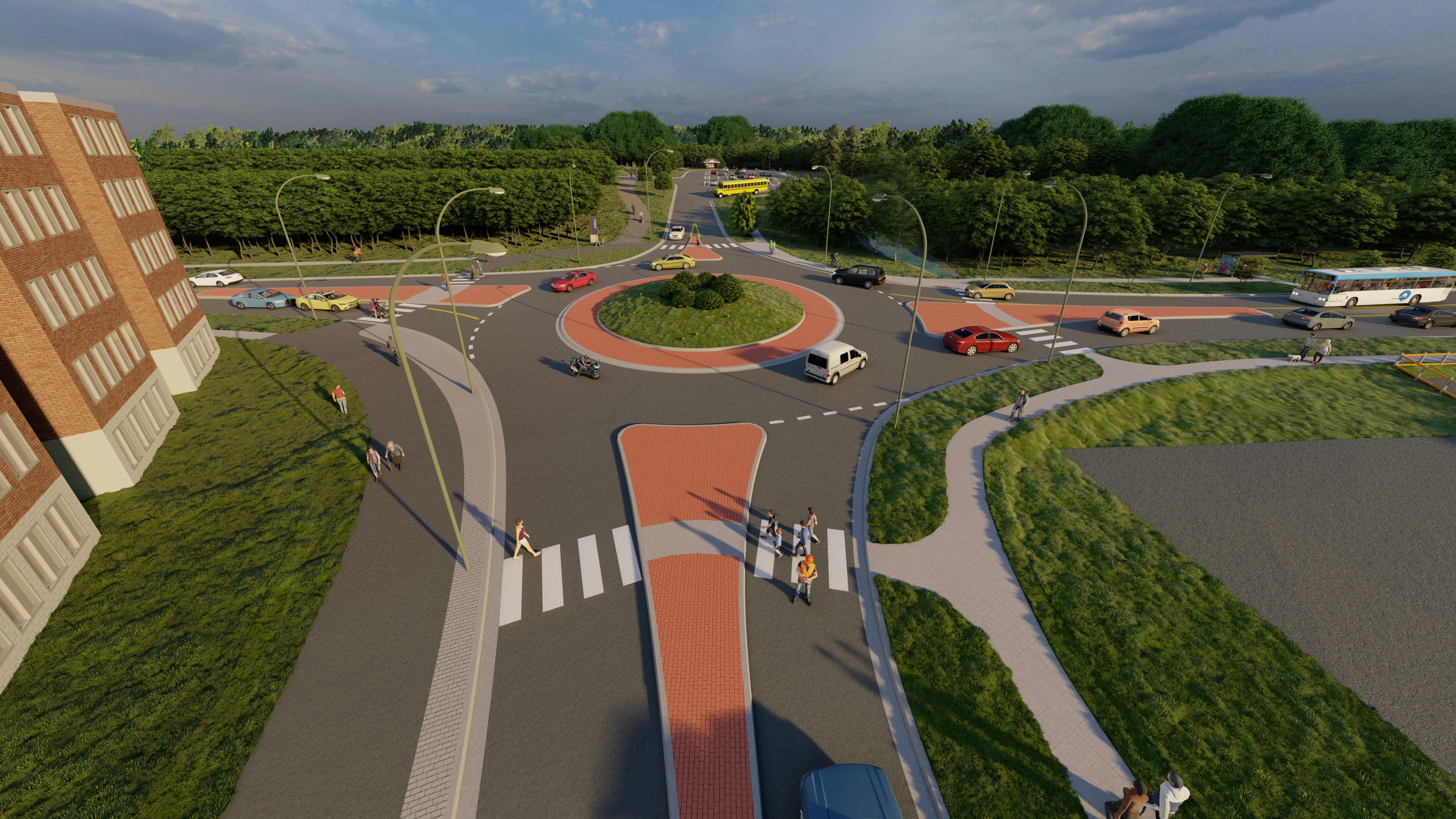
The sidewalk that is currently in place on Rookwood Avenue will remain once the project is complete. Because of this, students will not be required to make any new crossings or change the way they travel to school. The multi-use trail will be a safer corridor, not because the current sidewalk is unsafe, but because it provides users traveling between Odell Park and Wilmot Park a more direct route by reducing the number of street crossings. When new trails are added, road and driveway crossings are looked at by designers try to minimize crossings. This makes a safer and more enjoyable atmosphere for the users.
The crosswalks have been designed to provide good visibility to pedestrians and a crossing guard will also be there to assist the same way they did before. So, students walking to school will not need to make any changes to the route that they take and will benefit from the work that is being. The driveway for the new apartments will be located off Rookwood and located far enough away from the roundabout to permit drivers to safely enter and exit. The apartment building is also set back far enough to not create sightline issues for the driveway or the roundabout.
Share When the work begins will the students from Sunshine Gardens who walk daily to Connaught St school still be able to access the sidewalk? Will the crossing guard still be available? on Facebook
Share When the work begins will the students from Sunshine Gardens who walk daily to Connaught St school still be able to access the sidewalk? Will the crossing guard still be available? on X (formerly Twitter)
Share When the work begins will the students from Sunshine Gardens who walk daily to Connaught St school still be able to access the sidewalk? Will the crossing guard still be available? on Linkedin
Email When the work begins will the students from Sunshine Gardens who walk daily to Connaught St school still be able to access the sidewalk? Will the crossing guard still be available? link
When the work begins will the students from Sunshine Gardens who walk daily to Connaught St school still be able to access the sidewalk? Will the crossing guard still be available?
Amy Ferguson
asked
about 5 years ago
Thank you for your question. The construction schedule was chosen to accommodate the school schedule. Because of this, no work will take place in the intersection where the Waggoners lane crossing guard works until after the end of the school year.
Safe pedestrian access will be maintained at all times during the project. If the current sidewalk is being worked on, an alternate path will be clearly marked out and maintained to a fully accessible standard.
Share As was the case with the Victoria Circle, Parkhurst Drive will become a raceway through-fare. What traffic mitigation steps are being taken in a neighbourhood full of children and seniors? Speed bumps; police patrols (stop sign at Brookmont/Parkhurst has daily violations); other? And not just the signs that were used last time. on Facebook
Share As was the case with the Victoria Circle, Parkhurst Drive will become a raceway through-fare. What traffic mitigation steps are being taken in a neighbourhood full of children and seniors? Speed bumps; police patrols (stop sign at Brookmont/Parkhurst has daily violations); other? And not just the signs that were used last time. on X (formerly Twitter)
Share As was the case with the Victoria Circle, Parkhurst Drive will become a raceway through-fare. What traffic mitigation steps are being taken in a neighbourhood full of children and seniors? Speed bumps; police patrols (stop sign at Brookmont/Parkhurst has daily violations); other? And not just the signs that were used last time. on Linkedin
Email As was the case with the Victoria Circle, Parkhurst Drive will become a raceway through-fare. What traffic mitigation steps are being taken in a neighbourhood full of children and seniors? Speed bumps; police patrols (stop sign at Brookmont/Parkhurst has daily violations); other? And not just the signs that were used last time. link
As was the case with the Victoria Circle, Parkhurst Drive will become a raceway through-fare. What traffic mitigation steps are being taken in a neighbourhood full of children and seniors? Speed bumps; police patrols (stop sign at Brookmont/Parkhurst has daily violations); other? And not just the signs that were used last time.
Me
asked
about 5 years ago
Hi, and thanks for sharing your concerns with us. For the Waggoners Lane closure phase of this project, a detour route along Smythe Street – Woodstock Road – Hanwell Road will be clearly posted and the City of Fredericton will be communicating this detour route to the general public to encourage its use. In addition to this, we will be monitoring traffic along the detour corridor as well as surrounding neighborhoods throughout the project. If traffic delays are causing vehicles to use local streets, the city will modify signals timing to make the detour route the best and most attractive route possible. We ask that any specific speeding issues be shared with the Fredericton Police Force at the non-emergency number 460-2300. Thank you for your patience as we complete this important infrastructure project.